Sault Ste. Marie /ˌsuː seɪnt məˈriː/ is a city in and the county seat of Chippewa County in the U.S. state of Michigan.[4] It lies on the northeastern end of Michigan's Upper Peninsula, on the Canadian border, separated from its twin city of Sault Ste. Marie, Ontario, by the St. Marys River. The city is relatively isolated from other communities in Michigan. The population was 14,144 at the 2010 census, making it the second most populous city in the Upper Peninsula.
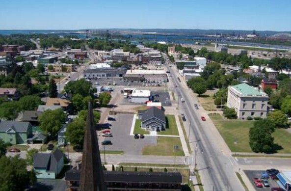
Sault Sainte Marie, taken from The Tower of History.
Sault Ste. Marie was already a place of Native American settlement 500 years ago. It became the first European settlement in the region that became the Midwestern United States,[5] when, in 1668, Father Jacques Marquette, having heard of the Native American village, traveled there to found a Catholic mission. A fur-trading settlement quickly grew at the crossroads that straddled the banks of the river, the center of a trading route of 3,000 miles (4,800 km) that extended from Montreal to the Sault, and from the Sault to the country north of Lake Superior.[6]
The settlement formed a single community until 1817, when a US–UK Joint Boundary Commission fixed the border between the Michigan Territory of the USA and the British Province of Upper Canada to follow the river in this area. The American and Canadian communities were each incorporated as municipalities toward the end of the nineteenth century.
Sault Sainte-Marie translates from French as "the Rapids of Saint Mary". The Saint Mary's River runs from Lake Superior to Lake Huron, separating the twin border cities.
No hyphens are used in the English spelling, which is otherwise identical to the French, but the pronunciations differ; Anglophones say/ˌsuː seɪnt məˈriː/ and Francophones say [so sɛ̃t maʁi]. In both languages, the name is often written Sault Ste. Marie. On both sides of the border, the towns and the general vicinity are called The Sault (usually pronounced/ˈsuː/) or The Soo.
The two cities are joined by the International Bridge, which connects Interstate 75 (i-75) in Sault Ste. Marie, Michigan, and Huron Street in Sault Ste. Marie, Ontario. Shipping traffic in the Great Lakes system bypasses the rapids via the American Soo Locks, the world's busiest canal in terms of tonnage passing through it,[citation needed] while smaller recreational and tour boats use the CanadianSault Ste. Marie Canal. The city's downtown sits on an island, with the locks to the north, and the Sault Ste. Marie Power Canal to the south.
People come from around the world to view shipping traffic pass through the locks. The largest ships are 1,000 feet (300 m) long by 105 feet (32 m) wide. These are domestic carriers (called lakers) too large to transit theWelland Canal that bypasses Niagara Fallsand, consequently, are land-locked. Foreign ships (termed salties) are smaller.
Sault Ste. Marie is also the home of the International 500 Snowmobile Race (commonly called the I-500), which takes place annually and draws participants and spectators from all over the U.S. and Canada. The race, which was inspired by the Indianapolis 500,[7] originated in 1969 and has been growing ever since.
History[]
For centuries Ojibwa (Chippewa) Native Americans had lived in the area, which they referred to as Baawitigong ("at the cascading rapids"), after the rapids of St. Marys River. French colonists renamed the region Saulteaux ("rapids").
In 1668, French missionaries Claude Dablon and Jacques Marquette founded a mission in the area, making it the third-oldest European city west of the Appalachian Mountains, and the oldest permanent settlement in contemporary Michigan state. On June 4, 1671, Simon-François Daumont de Saint-Lusson proclaimed France's appropriation of the immense territory surrounding Lake Superior in the name of King Louis XIV. Representatives of 14 indigenous nations were invited for the elaborate ceremony.[8]
In the 18th century, the settlement became an important center of the fur trade, when it was a post for the North West Company based in Canada. The fur trader John Johnston, aScots-Irish immigrant from Belfast, Ireland, was considered the first European settler in 1790. He married a high-ranking Ojibwa woman named Ozhaguscodaywayquay, the daughter of a prominent chief and his wife. She became known as Susan Johnston. Their marriage created an alliance with the Ojibwa, and the family was prominent among Native Americans, First Nations, and Europeans from Canada and the United States. They had eight children who spoke Ojibwe, English and French. The Johnstons entertained a variety of trappers, explorers, traders, and government officials, especially during the years before the War of 1812.[9]
As a result of the fur trade, the settlement became a settlement for Ojibwa and Ottawa,Métis, and ethnic Europeans of various nationalities. It was a two-tiered society, with fur traders (who had capital) and their families and upper-class Ojibwa in the upper echelon.[9] In the aftermath of the War of 1812, however, the community's society changed markedly.[9] The U.S. built Fort Bradynear the settlement, which introduced new troops and settlers, mostly Anglo-American. After completion of the Erie Canal in 1832, the number of settlers migrating to Ohio and Michigan increased dramatically. Their numbers overwhelmed the culture of the earlier settlers.
The falls proved a choke point for shipping. Early Lake Superior ships portaged around the rapids in a lengthy process (much like moving a house) that could take weeks. Later, only the cargoes were unloaded, hauled around the rapids, and then loaded onto other ships waiting below the rapids. The first American lock, the State Lock, was built in 1855; it was instrumental in improving shipping. Over the years, the lock was expanded and improved.
In 1900, Northwestern Leather Company opened a tannery in Sault Ste. Marie.[10] The tannery was founded to process dleather for the upper parts of shoes, which depended on finer leather.[11] After the factory closed in 1958, the property was sold to Filborn Limestone, a subsidiary of Algoma SteelCorporation.[12]
In March 1938, Sophia Nolte Pullar bequeathed $70,000 for construction of the Pullar Community Building, which opened in 1939. This building held an ice rink made of artificial ice, a then-revolutionary concept. The ice rink is still owned by the city.[13]
Meaning of the name[]
The city draws its name from the nearby rapids, which were called Les Saults de Sainte Marie – "Sainte Marie" (Saint Mary) being the name of the river, and "Saults" referring to the rapids.
The archaic spelling Sault is a relic of theMiddle French Period. Latin saltasuccessively became Old French salte (c. 800 – c. 1340), Middle French sault, and Modern French saut.
Whereas the modern saut means simply "(a) jump", sault was also applied to cataracts, waterfalls and rapids in the 17th century, hence the placenames Grand Falls/Grand-Sault, New/Nouveau Brunswick and Sault-au-Récollet on the Island of Montreal in Canada; and Sault-Saint-Remy and Sault-Brénaz, in France.
In contemporary French, "rapids" would berapides.
Transportation[]
- I‑75 ends nationally at the Sault Ste. Marie International Bridge at the Canadian border. On the Canadian side, drivers must use a series of city streets to connect withHighway 17, the local route of the Trans-Canada Highway.
- BS I‑75, Sault Ste. Marie
- M‑28
- M‑129
- H-63 (Mackinac Trail)
The city is the northern terminus of I-75, which connects with the Mackinac Bridge atSt. Ignace 52 miles (84 km) to the south, and continues south to Miami, Florida. M-129 also has its northern terminus in the city. M-129 was at one time a part of the Dixie Highwaysystem which was intended to connect the northern industrial states with the southern agricultural states. Until 1984 the city was the eastern terminus of the western segment ofUS 2. County Highway H-63 (or Mackinac Trail) also has its northern terminus in the city and extends south to St. Ignace and follows a route very similar to I-75. Commercial airline service is provided to the city by the Chippewa County International Airport in Kinross, about 20 miles (32 km) south. Smaller general aviation aircraft also use the Sault Ste. Marie Municipal Airportabout one 1 mile (1.6 km) southwest.
Sault Ste. Marie was the namesake of the Minneapolis, St. Paul and Sault Ste. Marie Railway, now the Soo Line Railroad, the U.S. arm of the Canadian Pacific Railway. This railroad had a bridge parallel to the International Bridge crossing the St. Marys River. The Soo Line has since, through a series of acquisitions and mergers of portions of the system, been split between Canadian Pacific and Canadian National Railway (CN), with CN operating the rail lines and the bridge in the Sault Ste. Marie area formerly part of the Soo Line.
The Sugar Island Ferry provides automobile and passenger access between Sault Ste. Marie and Sugar Island. The short route that the ferry travels crosses the shipping channel. Despite the high volume of freighter traffic through the locks, freighters typically do not dock in the Sault. However, the city hosts tugs, a tourist passenger ferry service, and a Coast Guard station along the shoreline on the lower (east) side of the Soo Locks. The United States Postal Service operates a "Marine Post Office", situated within the locks to service ships as they pass through.
Geography and climate[]
The city is located at Latitude: 46.49 N, Longitude: -84.35 W.
According to the United States Census Bureau, the city has a total area of 20.16 square miles (52.21 km2), of which 14.77 square miles (38.25 km2) is land and 5.39 square miles (13.96 km2) is water.[1]
Climate[]
Under the Köppen climate classification, Sault Ste. Marie has a humid continental climate (Dfb) with cold, snowy winters and warm summers.[14] Sault Ste. Marie is one of the snowiest places in Michigan, receiving an average of 128 inches (3.3 m) of snow a year, with a record year when 209 inches (5.3 m) fell. 62 inches (1.6 m) of snow fell in one five-day snowstorm, including 28 inches (710 mm) in 24 hours, in December 1995. Sault Ste. Marie receives an average annual 34 inches (860 mm) of precipitation measured as equivalent rainfall. Its immediate region is also the cloudiest in the UP, having over 200 cloudy days a year.
Temperatures in Sault Ste. Marie have varied between a record low of −36 °F (−38 °C) and a record high of 98 °F (37 °C). Monthly average temperatures range from a low of 13 °F (−11 °C) in January to a high of 64 °F (18 °C) in July.[15] On average, only two out of every five years reaches 90 °F (32 °C) while there are 85.5 days annually where the high remains at or below freezing and 26.5 nights with a low of 0 °F (−18 °C) or colder.
- Satellite image from June 2007.
- Sault Ste. Marie, Michigan Saint Marys Falls Hydropower Plant generation station.
- Astronaut photograph of Sault Ste. Marie.
| Climate data for Sault Ste. Marie, Michigan (1981–2010 normals, extremes 1888–present) | |||||||||||||
|---|---|---|---|---|---|---|---|---|---|---|---|---|---|
| Month | May | Year | |||||||||||
| Record high °F (°C) | 54 (12) |
50 (10) |
83 (28) |
85 (29) |
91 (33) |
93 (34) |
98 (37) |
98 (37) |
95 (35) |
82 (28) |
74 (23) |
62 (17) |
98 (37) |
| Average high °F (°C) | 23.0 (−5) |
25.9 (−3.4) |
34.7 (1.5) |
49.4 (9.7) |
62.7 (17.1) |
71.3 (21.8) |
76.2 (24.6) |
74.7 (23.7) |
66.5 (19.2) |
53.3 (11.8) |
40.1 (4.5) |
28.6 (−1.9) |
50.53 (10.3) |
| Average low °F (°C) | 7.6 (−13.6) |
9.4 (−12.6) |
17.9 (−7.8) |
31.1 (−0.5) |
40.9 (4.9) |
48.7 (9.3) |
54.4 (12.4) |
54.5 (12.5) |
47.7 (8.7) |
37.8 (3.2) |
28.1 (−2.2) |
15.8 (−9) |
32.83 (0.44) |
| Record low °F (°C) | −36 (−38) |
−37 (−38) |
−27 (−33) |
−13 (−25) |
18 (−8) |
26 (−3) |
36 (2) |
29 (−2) |
25 (−4) |
15 (−9) |
−12 (−24) |
−31 (−35) |
−37 (−38) |
| Precipitationinches (mm) | 2.19 (55.6) |
1.34 (34) |
1.95 (49.5) |
2.39 (60.7) |
2.57 (65.3) |
2.70 (68.6) |
2.86 (72.6) |
3.17 (80.5) |
3.82 (97) |
3.80 (96.5) |
3.37 (85.6) |
2.79 (70.9) |
32.95 (836.8) |
| Snowfall inches (cm) | 31.4 (79.8) |
18.6 (47.2) |
13.4 (34) |
6.7 (17) |
0.1 (0.3) |
0 (0) |
0 (0) |
0 (0) |
trace | 1.6 (4.1) |
15.1 (38.4) |
33.5 (85.1) |
120.4 (305.8) |
| precipitation days (≥ 0.01 in) | 18.4 | 13.0 | 12.3 | 10.9 | 11.2 | 11.1 | 11.2 | 10.9 | 12.9 | 15.5 | 16.7 | 18.8 | 162.9 |
| snowy days (≥ 0.1 in) | 19.6 | 14.2 | 10.1 | 4.6 | 0.4 | 0 | 0 | 0 | 0.1 | 2.2 | 10.0 | 18.0 | 79.2 |
| Mean monthlysunshine hours | 104.9 | 142.5 | 206.4 | 227.5 | 280.3 | 281.2 | 303.6 | 248.9 | 172.9 | 122.6 | 70.4 | 77.4 | 2,238.6 |
| Source: NOAA (sun 1961–1990)[16][17] |
DemographicsEdit[]
| Historical population | |||
|---|---|---|---|
| Census | |||
| 1860 | 596 | ||
| 1880 | 1,947 | ||
| 1890 | 5,760 | 195.8% | |
| 1900 | 10,538 | 83.0% | |
| 1910 | 12,615 | 19.7% | |
| 1920 | 12,096 | −4.1% | |
| 1930 | 13,755 | 13.7% | |
| 1940 | 15,847 | 15.2% | |
| 1950 | 17,912 | 13.0% | |
| 1960 | 18,722 | 4.5% | |
| 1970 | 15,136 | −19.2% | |
| 1980 | 14,448 | −4.5% | |
| 1990 | 14,689 | 1.7% | |
| 2000 | 16,542 | 12.6% | |
| 2010 | 14,144 | −14.5% | |
| Est. 2012 | 14,194 | 0.4% | |
| source:[18] |
2010 census[]
As of the census[2] of 2010, there were 14,144 people, 5,995 households, and 3,265 families residing in the city. The population densitywas 957.6 inhabitants per square mile (369.7 /km2). There were 6,534 housing units at an average density of 442.4 per square mile (170.8 /km2). The racial makeup of the city was 74.8% White, 0.7% African American, 17.7% Native American, 0.9% Asian, 0.1%Pacific Islander, 0.3% from other races, and 5.5% from two or more races. Hispanic orLatino of any race were 1.5% of the population.
There were 5,995 households of which 28.1% had children under the age of 18 living with them, 35.0% were married couples living together, 14.5% had a female householder with no husband present, 5.0% had a male householder with no wife present, and 45.5% were non-families. 35.7% of all households were made up of individuals and 12.8% had someone living alone who was 65 years of age or older. The average household size was 2.22 and the average family size was 2.88.
The median age in the city was 33.8 years. 21.3% of residents were under the age of 18; 17.1% were between the ages of 18 and 24; 23.8% were from 25 to 44; 23.8% were from 45 to 64; and 13.9% were 65 years of age or older. The gender makeup of the city was 48.5% male and 51.5% female.
2000 census[]
Note: After going through the Census 2000 Count Question Resolution Program, the population of the city in 2000 was revised to 14,324 because of the misallocation of some of a neighboring municipality's population to the city of Sault Ste. Marie.[19]
As of the census[20] of 2000, there were 16,542 people, 5,742 households, and 3,301 families living in the city. The population density was 1,116.3 people per square mile (431.0/km²). There were 6,237 housing units at an average density of 420.9 per square mile (162.5/km²). The racial makeup of the city was 73.99% White, 6.51% African American, 13.72% Native American, 0.65%Asian, 0.05% Pacific Islander, 0.47% fromother races, and 4.61% from two or more races. Hispanic or Latino of any race were 1.86% of the population.
There were 5,742 households out of which 28.8% had children under the age of 18 living with them, 39.9% were married couples living together, 13.2% had a female householder with no husband present, and 42.5% were non-families. 33.8% of all households were made up of individuals and 13.3% had someone living alone who was 65 years of age or older. The average household size was 2.28 and the average family size was 2.92.
In the city the population was spread out with 19.4% under the age of 18, 18.1% from 18 to 24, 31.9% from 25 to 44, 18.2% from 45 to 64, and 12.5% who were 65 years of age or older. The median age was 33 years. For every 100 females there were 122.0 males. For every 100 females age 18 and over, there were 128.3 males.
The median income for a household in the city was $29,652, and for a family was $40,333. Males had a median income of $29,656 versus $21,889 for females. The per capita income for the city was $14,460. About 12.7% of families and 17.5% of the population were below the poverty line, including 19.6% of those under age 18 and 12.5% of those age 65 or over.
Economy[]
Tourism is a major industry in the area. The Soo Locks and nearby Kewadin Casino, owned by the Sault Tribe of Chippewa Indians, are the major draws, as well as the forests, inland lakes, and Lake Superior shoreline. Sault Ste. Marie is also a gateway to Lake Superior's scenic north shore through its twin city Sault Ste. Marie, Ontario. The two cities are connected by the large Sault Ste. Marie International Bridge, a steel truss arch bridge with suspended deck passing over the St. Marys River.
Education[]
LSSU's campus was originally Fort Brady.
University[]
Sault Ste. Marie is home to Lake Superior State University (LSSU), founded in 1946 as an extension campus of Michigan College of Mining and Technology (now Michigan Technological University); the campus was originally Fort Brady. LSSU is home to the LSSU Lakers (D1 Hockey (CCHA), D2 all other sports (GLIAC). LSSU has around 2500 students, making it Michigan's smallest public university.
High School[]
The Sault's primary public high school is Sault Area High School. "Sault High" is one of the few high schools in the state with attached career center. The school's mascot is the Blue Devil. "Sault High" houses a variety of successful varsity sports teams, such as baseball and basketball. All together, the school provides 24 competitive sports teams for both boys and girls at all levels. [21]
The school district also operates Malcolm High School, as an alternative school.
Middle School[]
Sault Ste. Marie has two middle schools, one in the Sault Ste. Marie School System known as Sigma Area Middle School. Before the 6th grade annex was added in the late 1980s, the school was referred to as Sault Area Junior High School. The Second Middle School is a part of Joseph K. Lumsden Bahweting School, a Native American-affiliated Public School Academy.
Elementary School[]
There are several elementary schools in Sault Ste. Marie and the surrounding area, including Lincoln Elementary, Washington Elementary, Soo Township Elementary, in the Sault Ste. Marie School System, There is also a Public School Academy, Joseph K. Lumsden Bahweting School, and the St. Mary's Catholic School. In the last decade Jefferson Elementary, McKinley Elementary and Bruce Township Elementary have closed because of declining enrollment.
Private School[]
The Sault also has a number of private schools, including St. Marys School.
Media[]
TV[]
For stations licensed to Sault Ste. Marie, Ontario, see Media in Sault Ste. Marie, Ontario#Television.
All stations listed here are rebroadcasters of television stations based in Traverse City andCadillac.
- Channel 8: WGTQ, ABC (rebroadcasts WGTU); NBC on digital subchannel 8.2(rebroadcasts WPBN-TV)
- Channel 10: WWUP, CBS (rebroadcasts WWTV); Fox on digital subchannel 10.2(rebroadcasts WFQX-TV)
- Channel 28: W28DY-D, 3ABN (all programming via satellite)
NBC is also served by WTOM channel 4 fromCheboygan, which repeats WPBN-TV.
The area has no local PBS service over-the-air; on Charter's cable system, WNMU-TVfrom Marquette offers PBS programming.
None of these stations are seen on cable in the Canadian Soo, as Shaw cable airs Detroitand Rochester channels instead.
Radio[]
For stations licensed to Sault Ste. Marie, Ontario, see Media in Sault Ste. Marie, Ontario#Radio.
- 1230 AM – WSOO (adult contemporary/news/sports)
- 1400 AM – WKNW (talk/sports)
- 90.1 FM – WLSO, Lake Superior State University college radio
- 91.5 FM – WJOH (Contemporary Christian) "Smile FM" (rebroadcasts WLGH from Lansing)
- 98.3 FM – WCMZ (NPR) (rebroadcastsWCMU-FM from Mount Pleasant)
- 99.5 FM – WYSS (contemporary hit radio)
- 101.3 FM – WSUE (active rock)
- 102.3 FM – WTHN (religious) (rebroadcasts WPHN-FM from Gaylord)
- 103.3 FM – W277AG (religious)(rebroadcasts WHWL-FM from Marquette)
Other stations serving the Sault Ste. Marie, Michigan, market:
- 93.9 FM – WNBY (oldies) – Newberry, Michigan
- 95.1 FM – WUPN (classic hits) – Paradise, Michigan
- 97.9 FM – WIHC (Christian talk) – Newberry, Michigan
- 105.5 FM – WMKD (country) – Pickford, Michigan
Print[]
The city's main daily and newspaper of recordis the Sault Ste. Marie Evening News, more commonly referred to as the Evening News.
Notable people[]
- Terry O'Quinn, best known for playing John Locke from the hit ABC show, Lost, was born in Sault Ste. Marie
- John Johnston (1762–1828), married toOzhaguscodaywayquay (also known as Susan), the daughter of an Ojibwa chief; together they built a prosperous fur trading business. They were among the upper class in both the Euro-American and Ojibwa communities of the region during the late-18th and early-19th centuries.[22]
- Bruce Martyn, radio and TV play-by-play announcer of the Detroit Red Wings from 1964 to 1995. Martyn graduated from Lake Superior State University and began his radio career at WSOO.
- Chase Osborn, Michigan's only Governor from the Upper Peninsula.
- Jane Johnston Schoolcraft, daughter of John and Susan Johnston, recognized as the first Native American literary writer and poet, and inducted into Michigan Women's Hall of Fame in 2008.
- Henry Rowe Schoolcraft, ethnographer and U.S. Indian agent who named many counties and places in Michigan in his official capacity; husband of Jane Johnston Schoolcraft.
- Taffy Abel, National Hockey League player.
- Cliff Barton, former NHL player.
- Tip O'Neill, former NFL player.
- Lloyd H. Kincaid, former Wisconsin State Senator.
Notable landmarks[]
- Pullar Stadium was constructed starting in 1937 and opened in 1939. It is currently being used as an ice arena where the Soo Eaglesand the Sault High Blue Devils play.[13]
- The Ramada Plaza Hotel Ojiway opened on December 31, 1927. The first owners were Beatrice and Leon Daglman. The building is 85 years old. The 27th Governor of MichiganChase S. Osborn donated the site and $50,000 dollars. It was his dream to build a nice elegant hotel. Overall, it cost $250,000 dollars to build it. On the day of its opening it had 91 rooms, 33 of which included bath tubs, 13 with showers, 34 with toilet and washbowls, and 11 just had a washbowl. This hotel was made for all the tourist who came to the town. Governor Chase S. Osborn and his family lived on the sixth floor for a while and so did Beatrice and Leon Daglman. The hotel contains 100 guestrooms, dining room, checkroom, barbershop and beauty parlor. Its decorated as an Egyptian architectural design, décor, detailed amenities and exceptional service gained national interest and attracted many famous guests including Jack Dempsey, Joe Louis and more recently President George H.W. Bush in 1992(Ramada Hotel)[23]
- The Soo Theatre has been a part of Sault Ste. Marie for over 80 years and has provided entertainment of live plays, movies, and musicals. The Theatre opened in March 1930 and for 40 years was used for films and live performances. In May 1974 the theater was divided into red and blue cinemas, where a cement wall divided the once open auditorium. The building was then closed in 1998 and was put up for sale. In March 2003 the Soo Theatre Project Inc. purchased it for $85,000. After that the theater began restoration so that plays and other types of entertainment could be put on once again.[24]
Sister Cities[]
- Ryūō, Shiga, Japan
- Sault Ste. Marie, Ontario, Canada (alsotwin city)[25]