| Tahquamenon Falls | |
|---|---|
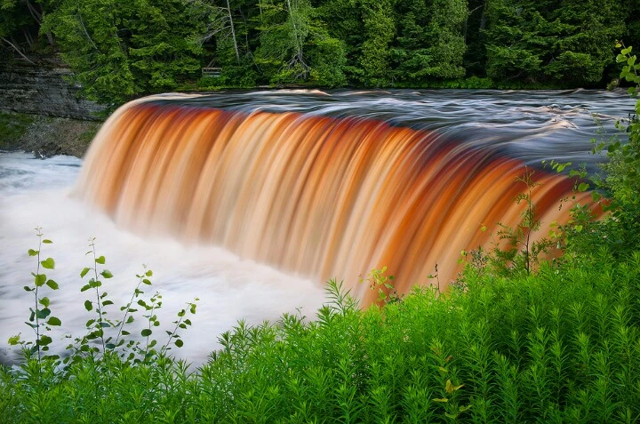 | |
| Location | Tahquamenon Falls State Park, Luce County, Michigan |
| Coordinates | 46.574°N 85.256°W |
| Type | Block |
| Total height | 48 ft |
| Number of drops | 77 |
| Watercourse | Tahquamenon River |
| Average flow rate |
7,000 gallons per second (average annual mean) |
The Tahquamenon Falls are two different waterfalls on the Tahquamenon River. Both sets are located near Lake Superior in the eastern Upper Peninsula of Michigan. The water is notably brown in color from the tannins leached from the cedar swampswhich the river drains. The upper falls are more than 200 feet (60 m) across and with a drop of approximately 48 feet (14 m) During the late spring runoff, the river drains as much as 50,000 US gallons (190,000 L) of water per second, making the upper falls the third most voluminous vertical waterfall east of the Mississippi River, after Niagara Fallsand Cohoes Falls, both in New York State. There is no jumping off the falls.
The lower falls, located four miles (6.5 km) downstream, are a series of five smaller falls cascading around an island which can be reached by rowboat. A hiking trail runs between the falls along the riverside, and visitors often play in the lower falls during the summer heat.
The falls are within Tahquamenon Falls State Park, between Newberry, Michigan, andParadise, Michigan. They are a popular tourist destination in the Upper Peninsula during all seasons. Snowmobile trails lead almost to the falls, and walkways are kept clear for most of the winter.
The Tahquamenon is noted as being the land of Longfellow's The Song of Hiawatha - "by the rushing Tahquamenaw" where Hiawatha built his canoe. "Tahquamenon Falls" is also a song from Sufjan Stevens's album Michigan.
While the name Tahquamenon is now primarily associated with the falls, it appears to have originally designated an island inWhitefish Bay: Tahquamenon Island. The first written record of the name appears as "Outakouaminan" in a 1671 French map.[1]
The upper falls are located at 46°34′29″N85°15′23″W and the lower falls are at46°36′12″N 85°12′25″W